측량학 - Positioning GPS control points in Korea


측량학 - Positioning GPS control points in Korea

측량학 - Positioning GPS control points in Korea
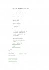
1. Title
Positioning GPS control points in Korea
2. Introduction
한반도 주위를 도는 7~8개의 위성으로부터 받은 GPS정보를 Matlab 프로그램을 통해 계산, PDOP값을 구하여 residual값을 계산, 비교한다. 이를 위해 Taylor series, Least square method 를 사용한다.
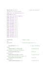
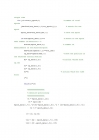
3. Materials and Methods
Assuming that the standard deviation is 0.3 m, make a MATLAB
program to calculate receiver position.
1. Choose any one control point
2. Calculate the receiver position epoch by epoch
3. Plot the relative position changes with respect to the time
changes (hour)
4. Overplot the GDOP changes with respect to the time changes
Note:
1) Use the CP positions as initial inputs for iterations
2) Use only the GPS data with elevation angle ] 15°
3) Use only the epoch data with the number of satellites ] 3
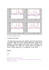
4. Results
n=8, 상주의 GPS residual 그래프
5. Discussion and Conclusion
....
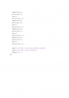
1. Title
Positioning GPS control points in Korea
2. Introduction
한반도 주위를 도는 7~8개의 위성으로부터 받은 GPS정보를 Matlab 프로그램을 통해 계산, PDOP값을 구하여 residual값을 계산, 비교한다. 이를 위해 Taylor series, Least square method 를 사용한다.
3. Materials and Methods
Assuming that the standard deviation is 0.3 m, make a MATLAB
program to calculate receiver position.
1. Choose any one control point
2. Calculate the receiver position epoch by epoch
3. Plot the relative position changes with respect to the time
changes (hour)
4. Overplot the GDOP changes with respect to the time changes
Note:
1) Use the CP positions as initial inputs for iterations
2) Use only the GPS data with elevation angle ] 15°
3) Use only the epoch data with the number of satellites ] 3
4. Results
n=8, 상주의 GPS residual 그래프
5. Discussion and Conclusion
....

-
 GPS 이해 자료 ppt
GPS의 이해 GPS 목차 GPS 정의 및 소개 GPS 장점, 단점 및 오차 GPS 종류 GPS 사용용도 및 제품소개 향후 GPS의 발전방향 GPS 정의 및 소개 GPS란 GPS 역사 GPS 원리 GPS 구성 GPS란 GPS(Globa.. -
ZARA,ZARA마케팅전략,ZARA기업분석,자라마케팅전략,자라기업분석,자라영문마케팅,영문마케팅,영어마케팅
ZARA Supply Chain Management Table of contents 1 An introduction to ZARA 2 Fast Fashion SPA System 3 Supply Chain Management 4 Position in the Domestic Fashion industry 5 Problem Points have to com.. -
블랙박스
2011년 6월에 출시을 했읍니다 블랙박스의 신기술을 적용을 했읍니다 *1.3 million pixel high performance camera is loaded. *Smooth high-definition video at 30 frames a vision of the Week and of the Nig.. -
측량학 및 실험 - LidDAR의 정의 및 활용사례
[측량학 및 실습] Light Detection and Ranging L i D A R 목 차 LiDAR란 LiDAR의 원리 LiDAR 데이터 처리 LiDAR의 활용 사례 LiDAR의 향후 활용방향 1. LiDAR란 LiDAR (Light Detection And Ranging)는 레이.. -
Personnel Profile Document
Personnel Profile Document Personal Data Name In English Birth of Date Photo In Korean Sex Passport No. Nationality Home Country Home Address Previous Employer Position In Korea Address C.. -
영문 이력서 예2
영문 이력서 예2 Gil- Dong Hong Seoul, Korea OBJECTIVE : Marketing Position in Consumer Product or Service Industry QUALIFICATION * Extensive marketing courses with real cases and projects. * B.. -
영문이력서(마케팅)
Gil Dong Hong Seoul, Korea OBJECTIVE : Marketing Position in Consumer Product or Service Industry QUALIFICATION * Extensive marketing courses with real cases and projects. * Broad knowled.. -
GPS ( Global Position System)
제 목 : G P S ( Global Position System) GPS란 무엇인가 GPS의 등장배경 GPS의 원리 GPS위성의 측정 원리 GPS의 위성 배치 GPS의 특징 GPS의 구성 - 우주부문 - 관제부문 - 사용자부문 GPS수신기의 .. -
[과학기술] GPS에 관한 조사
GPS 1. GPS의 정의 범 지구 측위 시스템(GPS : Global Positioning System)은 미국 정부가 1970년대 초반부터 개발에 착수하여 약 60억불의 예산을 투자하여 구축한 항법지원시스템 으로 육상, 해상, 공중 등 지.. -
gps 분석
G P S Contents GPS란 GPS의 원리 GPS와 GIS GPS의 활용 GPS단말기의 작동원리 GPS의 종류 GPS란 GPS는 Global Positioning System(전세계 위치 표시 시스템: 위성 항법 장치)의 약어 위성으로부터 거리를 측정하..